|
|
|
Shoreline Fishing Access
Space
Coast North, Freshwater
|
|
(State Road-46 Lake Harney Area to
SR-528 Cocoa)
|
|
|
| |
Six Mile Creek;
5900 State Road 46, Mims
FROM I-95 take SR-46 Exit-223, go west 5.9
miles on W Main St/SR-46. The entrance is on
the north side of the road.
Boat ramps open 24 hours a day.
Located in the Six Mile Creek Wildlife
Refuge, this 4.15-acre community river park
features a boat ramp with unpaved parking
for up to 50 cars and boat trailers. The
ramp allows access to the St. John’s River
six miles southwest through Little Salt
Lake, Salt Lake, Loughman Lake and Clark
Lake. This ramp is best reserved for smaller
boats and Gheenoes.
ADA ACCESS: Advance notice needed for
special accommodations.
GPS N 28 39.960 W 80 54.668
Google Satellite Image |
| |
Hatbill Park
100 Hatbill Road, Mims
FROM I-95, take SR-46 Exit-223 west towards
Mims/Sanford. Stay on SR-46 for 4.1 miles to
Hatbill Road. Turn left and go 8.5 miles to
the Hatbill Rd/Baxter Point Rd intersection,
keep left and go 0.5 miles to the park.
Boat ramp open 24 hours a day.
This 15-acre park offers sport fishing from
shoreline or boat. Features include a boat
ramp accessing the St. Johns River and
port-o-lets. Primitive camping by permit on
weekends. Call 321-264-5037 for permit and
info.
GPS N 28 36.351 W 80 57.731
Google Satellite Image |
| |
C.S. Lee Park(Seminole County)
4600 E. State Road 46
Geneva, FL 32732
Phone: (407) 788-0405
Heading east on State Road 46 from I-95, you
will pass through a sliver of Volusia
County, then cross the St John's River and
the park will be on the right. This park is
open 24 hours a day. There is a small area
offering shoreline fishing on the north side
of the boat ramp.
GPS N 28 42.897 W 81 02.140
Google Satellite Image |
| |
|
Loughman Lake Lodge
1955 Hatbill Rd, Mims, FL. (321)
268-2277
Loughman Lake Lodge is a lodge on Loughman
Lake that can be accessed from Hatbill Road.
Follow the directions for Hatbill Park just
above from I-95 to Hatbill Road. Soon after
entering Hatbill Road you will see the signs
for the Lodge on the left side. Follow
signs. It is a privately owned lodge with a
restaurant, RV sites, tent camping, and
several cabins for rent. They offer Airboat
tours of the St. John's from here and there
is also a pay per use boat ramp. They do
allow shoreline fishing on their property
without charge for day visitors (Verified by
phone call). Word of Caution; It is
very easy to become trapped in this
wilderness setting due to the fact that they
serve great food, cold beer, a great view of
the St. John's River Wilderness from the
restaurant and bar, live bands, biker
parties, airboat races, kids activity days
and other distractions which could entirely
ruin a day of fishing!!
GPS N 28 38.774 W 80 56.270
Google Satellite Image
|
| |
Holder Park;
2650 Glendale Boulevard, Mims
Parks Referendum Project
FROM US Hwy 1, go 0.9 miles west on Parrish
Road, turn right on Glendale Boulevard and
go 0.7 miles to the park.
Open after 7:00 a.m. until dark, except for
scheduled use.
This park is primarily known as a little
league baseball park and fishing is not
listed on the Brevard County Website as an
activity here, however there is a freshwater
pond of about 2 acres on the north end of
the park. It is legal to fish there,
verified by phone call to Brevard Parks and
Recreation.
GPS 28.658103,-80.859375
Google Satellite Image |
| |
|
Chain of Lakes
Snowy Egret Drive, Titusville
Parks Referendum Project
FROM I-95, take SR-46 Exit 223 toward Mims,
and go east on W. Main Street (FL-46) 1.5
miles. Turn RIGHT onto US Hwy 1, go 1.5
miles then left on Jay Jay Road. The
entrance to Snowy Egret Drive is on the
right.
FROM US Hwy 1, turn east onto E. Jay Jay Rd
(.3 miles north of Dairy Rd or .5 miles
south of Parrish Rd). The entrance to Snowy
Egret Drive is on the right.
Open after 7:00 a.m. until dark.
Chain of Lakes is a regional stormwater park
and athletic facility, containing soccer
fields, softball fields, a walking trail and
a large stormwater retention lake east of
the fields that has been stocked with
freshwater gamefish. Due to the fact it is a
stormwater facility it is posted as catch
and release only.
GPS N 28 38.584 W 80 49.642
Google Satellite Image
|
| |
|
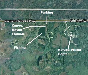 Merritt
Island National Wildlife Refuge South Barrow
Pits; Merritt
Island National Wildlife Refuge South Barrow
Pits;
Take the Max Brewer Causeway to the
Refuge on State Road 406 and follow the road
as it turns to the right at the Black Point
Wildlife Drive. Just before you reach the
entrance to the Wildlife Refuge Visitor's
Center you will see a pull off to your right
with a barricaded Trail. You can pull up to
the barricade and off to the side and park.
Just beyond there will be a canoe launch
area and just down the trail a bit is a
fishing dock overlooking the first pond. The
Refuge personel advise catch and release
fishing only due to elevated mercury levels
in the fish of unknown origin.
GPS N 28 38.577 W 80 44.399
Google Satellite Image
|
| |
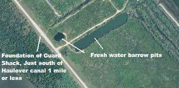 Merritt
Island National Wildlife North Refuge Barrow
Pits; If you continue on 402 past the
Visitor Center and turn left toward Haulover
Canal, about a mile south of the Canal you
will see two Barrow Pits on the East side of
the Road. Pull of onto the dirt road and
pull to the side so others can access ther
Mosquito Lagoon just to the east. Again
Refuge personel advise catch and release
fishing only due to elevated mercury levels
in the fish of unknown origin. Merritt
Island National Wildlife North Refuge Barrow
Pits; If you continue on 402 past the
Visitor Center and turn left toward Haulover
Canal, about a mile south of the Canal you
will see two Barrow Pits on the East side of
the Road. Pull of onto the dirt road and
pull to the side so others can access ther
Mosquito Lagoon just to the east. Again
Refuge personel advise catch and release
fishing only due to elevated mercury levels
in the fish of unknown origin.
GPS N 28 43.529 W 80 44.675
Google Satellite Image |
| |
Fox Lake Park
4400 Fox Lake Road, Titusville
Parks Referendum Project
FROM SR-50 AT SR-405, go north 2.1 miles on
SR-405, turn left and go 1.4 miles to the
end of Fox Lake Road (west of I-95).
Open after 7:00 a.m. until dark, except for
scheduled use.
Fox Lake park is a popular fishing area in
Titusville that has plenty of shoreline
fishing opportunities. In fact it is
probably one of the better shoreline
freshwater fisheries around. My second
largest largemouth bass came right off the
dock at this park, 7.5 lbs, on a live shiner
caught on breadballs at the dock. Also, this
lake has a good crappie fishery from shore
during the early spring.
GPS N 28 35.271 W 80 52.385
Google Satellite Image |
| |
Tosohatchee Wildlife Management Area;
(Orange County)
3365 Taylor Creek Road
Christmas, FL 32709-9130
(407) 568-5893
Tosohatchee Wildlife Management Area (WMA)
covers 30,701 acres along 19 miles of the
St. Johns River in eastern Orange County.
There are several shorline fishing site you
can drive to. The shoreline of the St John's
can be access by driving into the entrance
road, (Beehead Road), pay fee at self pay
kiosk (a few bucks) and continue on Beehead
until the first left at Nicholas Road.
Proceed to next right at Powerline Road and
follow road to absolute end. It will feel
like forever and you will cross Jim Creek
over two rustic looking auto bridges. Don't
be afraid to fish the ditches on the side of
the road in some of the wider sections.
There are also several man made lakes along
the southern edge of the property. Take
Beehead from main entrance until you come to
Fish Hole Road, take a right and follow this
until it meets with Long Bluff Road, go
under State Road 528. One lake is on Long
Bluff Road while the other two are off of a
side road to the left of Long Bluff. You can
also try Tootoosahatchee Creek, which can be
accessed by a bridge over the creek, by
taking the entrance road to Nicholas,
turning left and following it past Powerline
Road to a parking trailhead just past the
Horse camp area. The creek will be a short
hike up this section of the Florida Scenic
Trail.
GPS N 28 29.912 W 80 59.903
Google Satellite Image (Entrance)
Google Satellite Image (St John's River
Shore)
Google Satellite Image (Lakes on Long Bluff)
Florida State Parks Website
The Florida National Scenic Trail Map 23,
Tosohatchee, covers this region and can be
purchased via the Florida Trail Association;
visit their Web site for an order form.
Florida Trail Association Website
Florida Fish and Wildlife Conservation
Commission Map
Out in the Boonies Website Good site! |
| |
Fay Lake Wilderness Park
6300 Fay Boulevard, Port St John
LOCATED west of I-95 at the end of Fay
Boulevard.
Open after 7:00 a.m. until dark, except for
scheduled use.
At the west end of Fay Boulevard, this
192.7-acre community park offers access to a
27-acre fishing lake. Shoreline fishing,
kayaking and small boats with electric
motors allowed.
GPS N 28 27.694 W 80 50.054
Google Satellite Image |
| |
Pine Island Conservation Area;
Take I-95 to the State Road (SR) 528
East exit to Merritt Island. Proceed east on
SR 528 approximately seven miles to the SR 3
exit. Turn left on SR 3 (north) over the
barge canal and go approximately five miles
to Pine Island Road. Turn left on Pine
Island Road and proceed 2.5 miles to the
main entrance gate located at the western
end of Pine Island Road. This site has both
freshwater pond and saltwater lagoon
fishing. but shore access may be somewhat
limited, particularly for salt.
Here's a couple of more websites and a
property map.
GPS N 28 29.552 W 80 43.302
Google Satellite Image
SJRWMD Website /
SJRWMD Property map |
| |
Kings Park
995 Chase Hammock Road, Merritt Island
FROM US Hwy 1, take SR-528 east 2.7 miles,
turn left onto Courtenay Parkway (SR-3) and
go 3.1 miles.Turn right and go 0.9 miles on
Chase Hammock.
Open after 7:00 a.m. until dark.
This 240-acre park is a haven for freshwater
fishing. Two lakes and a creek with a
multiuse trail make for an interesting
fishing location.
GPS N 28 26.840 W 80 41.690
Google Satellite Image |
| |
|
|
|
|


